Coney Island Map and Brochure (2005 – 2025)
Location: Cincinnati, Ohio
Years Active: 1870 – Active
Coney Island is a small water park located on the banks of the Ohio River in Cincinnati, Ohio, approximately 10 miles east of the downtown area in Anderson Township. It no longer has the old-time carnival rides pictured in many review sites and promotional materials still in use. As of the 2021 season, about one-third of the deep end is occupied by an inflatable obstacle course not pictured on the park’s website.
The park sits directly adjacent to Riverbend Music Center and Belterra Park. Beginning in 1870, the original owner called the area Parker’s Grove, which was later renamed Ohio Grove, The Coney Island of the West after the Ohio Grove Corporation purchased the park in 1886. The name was shortened to Coney Island the following season. Growth over the years spawned dozens of rides and attractions which led to its popularity as an amusement destination.
Coney Island was sold to Taft Broadcasting in 1969 with intentions to move the park to a new, larger destination away from frequent flooding. The new park opened as Kings Island in 1972, although Coney Island’s Sunlite Pool remained opened. Rides eventually returned, and additional investments and improvements were made to the Sunlite Pool area. These changes, along with the opening of the nearby Riverbend Music Center in 1984, allowed the park’s attendance and profitability to recover. In 2019, Coney Island focused its operations exclusively on its water park amenities and removed other amusement rides.
Need past editions? Browse the Old Coney Island Maps archive (2005–2025) with 7 map editions.
Coney Island Map 2025
In 2025, Coney Island marked the seasonal reopening of Luna Park on March 29 with its traditional Cyclone roller coaster first ride and egg cream christening, alongside 98th anniversary giveaways for early visitors. The park also debuted new arcade games, renovated retail vendors, and a refreshed Salt & Sizzle patio. Additionally, Deno’s Wonder Wheel Amusement Park reopened on April 13 for its 105th season with the annual Blessing of the Rides ceremony.
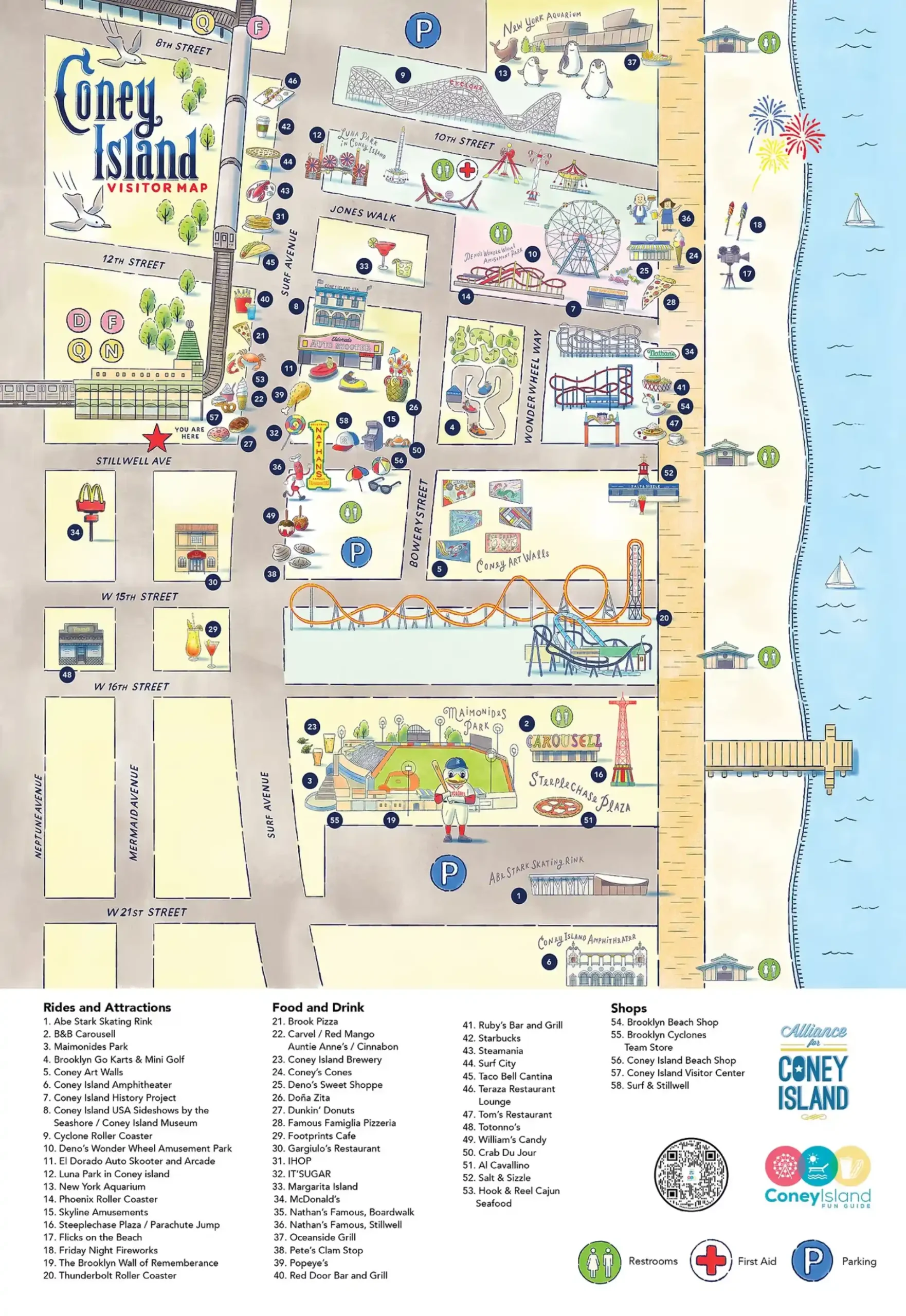
Printable Coney Island Map PDF 2025
FAQ
When did Coney Island in Ohio close?
Coney Island amusement park in Cincinnati, Ohio, permanently closed on December 31, 2023. The closure ended more than 130 years of operation. The site will be redeveloped into a concert venue by the owners of Riverbend Music Center. Its Sunlite Pool, once the largest recirculating pool in the world, also closed with the park.
Is Coney Island in Cincinnati still open?
Coney Island in Cincinnati is no longer open. The park closed permanently on December 31, 2023, after more than 130 years of operation. Its rides, attractions, and Sunlite Pool shut down, and the site will be redeveloped into a concert venue connected to Riverbend Music Center.
What happened to Coney Island amusement park?
Coney Island amusement park in Cincinnati closed permanently on December 31, 2023. The decision ended over 130 years of operation. All rides, attractions, and its famous Sunlite Pool shut down. The property will be redeveloped into a 20,000-seat concert venue by the owners of Riverbend Music Center.
What will happen to Coney Island, Cincinnati?
Coney Island in Cincinnati will be redeveloped into a 20,000-seat concert venue. The amusement park closed permanently on December 31, 2023, after more than 130 years. The owners of Riverbend Music Center will oversee the transformation, replacing rides and Sunlite Pool with a new live entertainment destination.