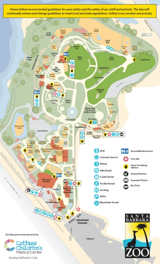
Santa Barbara Zoo Map (2024 – 2016)
Location: Santa Barbara, California
Years Active: 1963 – Active
This Santa Barbara Zoo map unlocks more than just animal exhibits. It’s your key to hidden experiences most visitors miss.
Craving a unique photo? Our printable map guides you to the capybaras during feeding time. Imagine rows of these giant rodents munching on mountains of veggies.
Curious about animal care? This map might lead you to a behind-the-scenes glimpse.
Feeling like a zoo pro? Navigate with confidence and ensure a memorable visit for everyone.
Santa Barbara Zoo Map 2024
Printable Santa Barbara Zoo Map PDF 2024
Santa Barbara Zoo Map 2022
Santa Barbara Zoo Map 2016
FAQ
How long does it take to walk the Santa Barbara Zoo?
It takes around 2 hours to walk through the Santa Barbara Zoo at a leisurely pace. This gives you time to see all the exhibits without rushing. However, if you’re traveling with young children or plan to linger at specific animal encounters, allow extra time.
How far is Santa Barbara Zoo from train station?
The Santa Barbara Zoo is 1.9 miles from the train station.
Does Santa Barbara Zoo have red pandas?
Yes, the Santa Barbara Zoo has red pandas! One of their red pandas is named Raj, who arrived in 2023. He lives in a habitat with a Burmese black mountain tortoise named Mathilda.


