Six Flags New Orleans Map 2026 PDF
Built on the edge of a bayou and boxed in by levees, Six Flags New Orleans was a park that always felt half-wild, half-urban. A Six Flags New Orleans map once helped you trace wooden coaster tracks skimming swamp grass, find the flood-prone midway that turned into a maze after rain, and spot the small train loop that connected everything before the heat took over.
- Location
- New Orleans, Louisiana
- Years Active
- 2000 – 2005
Food stands huddled near the lagoon, shows ran until the humidity fogged the lights, and the ferry-style bridge at the front gate was everyone’s meeting point.
It’s strange now to think how loud it once was, then again, silence is its loudest sound today.
Need past editions? Browse the Old Six Flags New Orleans Maps archive (2000–2005) with 6 map editions and 2 brochures.
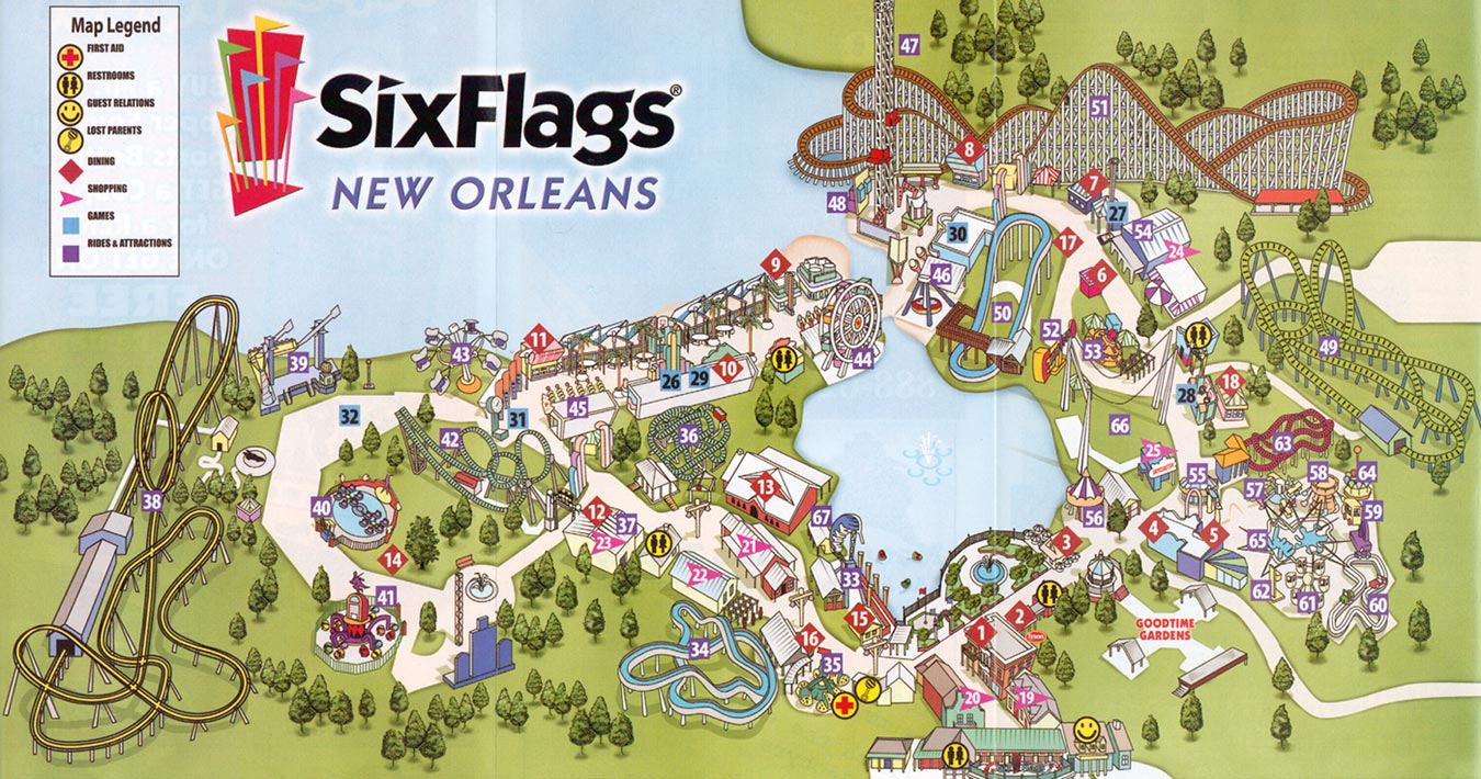
Six Flags New Orleans Map 2005
In 2005, Six Flags New Orleans permanently closed following the devastation of Hurricane Katrina. The park’s last operating day was August 21, with a planned reopening for August 27–28 canceled as the storm approached.
On August 29, Hurricane Katrina flooded the park under 12 feet of water, preventing it from ever reopening. Plans for a new water park to be announced later that month were also canceled due to the disaster.


FAQ
What happened to Six Flags in New Orleans?
Six Flags New Orleans was severely damaged by Hurricane Katrina in 2005 and has remained closed ever since. The park was abandoned after flooding, and all rides and structures were left to deteriorate. Attempts to redevelop or reopen the site have not succeeded, and it currently remains an abandoned property.
Is Six Flags New Orleans going to be demolished?
Six Flags New Orleans is currently being demolished as part of a redevelopment plan for the site. The demolition began in late 2024, experienced a brief pause due to contractor issues, and resumed with a new contractor; the process is expected to finish by March 2025. The property will be transformed into a complex featuring a youth sports complex, hotels, a movie studio, and other amenities.
What replaced Six Flags in New Orleans?
The former Six Flags New Orleans site is being redeveloped into a mixed-use complex called Bayou Phoenix. The new development includes a youth sports complex, hotels, retail space, and a film studio. Construction and redevelopment began after demolition was completed in early 2025.
Can you visit Six Flags New Orleans?
Six Flags New Orleans cannot be visited by the public. The site is closed, fenced off, and actively undergoing demolition and redevelopment as of 2025. Unauthorized entry is considered trespassing and is not permitted.